Flashback — Folk Art Center – Blue Ridge Parkway

At milepost 382 of the Blue Ridge Parkway, just outside of Asheville, NC, is the Folk Art Center, a wonderful place to stretch your legs and feast your eyes on some handmade beauty. Run by the Southern Highland Craft Guild, a century old artist’s organization, in cooperation with the National Park Service and the Appalachian Regional Commission, this gallery and gift shop offers seasonal exhibits and fine arts and crafts from around the region.

Here is a sampling of the quilts and folk art on display during my spring visit.

To learn more visit the Craft Guild website.

FYI – You will find other Craft Guild shops in Asheville, Gatlinburg, TN, Middlesboro, KY and at milepost 294 of the Parkway near Blowing Rock, NC.

Flashback — Mountain High

And now for the rest of the story —

As traBlue Ridge Parkway signvels, even meanders, always do, it came time to turn toward home. Leaving the coast behind, I headed West toward Asheville, North Carolina, the Blue Ridge Parkway and Great Smoky Mountains National Park a place I had lived for a few months just out of high school and other than to drive by occasionally on trips south had not visited again since my early 20s. I spent a couple of glorious days (not nearly enough) driving the parkway which traverses 469 miles through Virginia and North Carolina along the Blue Ridge, a part of the Appalachian Mountains, through tunnels and across streams and deep ravines, all with the glorious backdrop of the blue ridges for miles and miles.

Rising from Asheville at approximately 3000 feet above sea level to 6000+ several times, the climate changed from warm sunshine and blooming dogwoods to still naked trees and brisk wintery winds, then back to the warmth of spring in bloom again. Many scenic overlooks mark your way, along with great hiking opportunities, some easy and some more difficult, to waterfalls and places like Devil’s Courthouse (a cave where the wind makes it sound like someone is talking) and Looking Glass Rock (with a wet face that glows in the sun and shines like a mirror). (L-R below)

My favorite memory is the trip down from Mitchell Mountain, the highest point in the Eastern US. A section of the parkway was closed ahead and I would have had to backtrack at least 30 miles to reach a paved road going down the mountain. Having driven 50-60 miles out of my way, following the tourism office directions to reach the parkway the “easy” way (which I guess means less curves), I was not interested in backtracking that far. Discovering that I did not mind curves (what is with this curvaceous avoidance?), the ranger told me about a forest road shortcut down the side of the mountain that had just been graded, so of course I took it.

What a ride!

The road winds straight down the side of the mountain, switching back and forth and sometimes wrapping around itself, as it follows the terrain and a rushing stream. At the top there is nothing but late winter brown and dull conifers, but as you descend, tiny green leaves soften the stark branches of deciduous trees. Over and over you cross a stream which tumbles over dead fall and boulders — music to your ears. Before long, dogwoods in full bloom delight your eyes as you wind your way into spring warmth. At the bottom, an old mill attests to strength of the water’s flow.

Here are a few scenes from my drive.

This slideshow requires JavaScript.

Asheville is lovely. Like my hometown, Madison, WI (though only 1/4 the size), it is a small city that is big in beauty and culture. Throw in the Blue Ridge Parkway, the Great Smokys around the bend, and Southern charm plus music, artisans, and lots of organic food and you have a city I would love to call home.

In fact, when I came down the mountain to find a camp host in a very off-the-beaten-path federal campground just outside of town, I was very tempted to just stay right there and never leave.


Charleston Chew

I am not a big city bear. I enjoy a day trip to the city, walking amidst the tall buildings, window shopping, people watching, visiting museums and grand big city parks — even riding the subway can be fun. But I hate the chaos of traffic and trying to find a parking spot, especially in a big city that I am unfamiliar with, and even more so when I am the driver, navigator, and sole crash avoider.

Charleston, South Carolina signBeing on the Atlantic coast and reluctant to leave the water behind, I thought I’d take a chance on the city life and make like a Southern belle for a few hours in Charleston, South Carolina. After all, Charleston represents the founding of our nation, Southern charm, and more history than you can imagine.

The plan was to head downtown, take in some history, photograph antebellum homes for the folks back home, have a little dinner in a quaint local establishment in a 200+ year old neighborhood and then head to Asheville and the mountains.

Having avoided Savannah and taken a more direct secondary highway into the state, I missed the official welcome center so I had no state map. Just outside the city I came upon a tourist information center so I stopped to get a map. Being a private tourism office, they make their money from referrals to hotels and restaurants in Charleston; the agent had no state maps and she was not too pleased with my plan to just visit the city for a few hours and hit the road again. (Let’s just say she did not offer a stellar example of Southern hospitality.)

Olde Market, Charleston, South CarolinaThough I asked for directions to the historic area where I could see the antebellum homes and such, she directed me to the Olde Market area — “200 years old and lots of arts and crafts.” OK I am up for that.

Basket vendor, Olde Market, Charleston, South Carolina Niche hotel and horse drawn carriage, Charleston, South Carolina
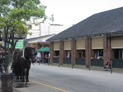
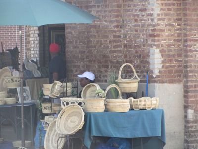
After navigating into the heart of the old city port area, where streets are twisted and narrow, one way and dead ended, driving around for 1/2 hour, dodging people, cars, and horse drawn carriages to find a parking spot, I found the olde market — a succession of 8 – 10 or more brick buildings with open ends and half walls filled with vendors. They have indeed stood here as a place to vend goods (originally from the ships in port and the plantations outside town) for 200 years.

The area was originally a warehouse district, though now the warehouses sport major chain and niche hotels, pubs, and restaurants for the tourists.

Baskets, Charleston, South Carolina
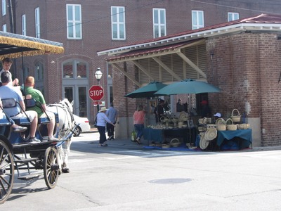
Since I was expecting “arts and crafts,” I was not prepared for the flea market atmosphere — a few handmade basket vendors (a Charleston specialty) and hand sewn bonnets, aprons, and household items, but stalls were mostly filled with 21st century junk “as seen on TV” or you’d find at K-mart. After walking through 3 buildings and literally finding nothing worth even pausing to look at (except the baskets – tourist priced), I bought a handmade lemonade and bolted back to my car. Following my own intuition and with the help of the lemonade vendor, I managed to make my way to White Point Gardens at the water’s edge.

This delightful couple blocks of green space, though under reconstruction in spots, offered a respite from the traffic and chaos. Walking around the area, I discovered the kind of historical homes, large and small, that I was looking for, towering live oaks dripping in Spanish moss, old brick and cobblestone streets, sections of the old city wall, gates offering glimpses of 200 year old courtyards and formal gardens, pavilions, statues, and more historical markers than you could count. Horse drawn carriages were everywhere, telling of the history of certain houses and residents (I guess taking the tour was the “seeing the antebellum houses” the tourism maven had in mind.)

Enjoy this photo tour of the area south of Broad.

This slideshow requires JavaScript.

Fort Sumter, Charleston, South CarolinaBeing a coastal city, a seawall and promenade, 6-feet high and wide enough for 4 people to walk abreast protects the homes from the sea (and served dual duty as a battery in times past (the canons now sit in the park.) From the top, you get a view of Fort Sumter where the Star Spangled Banner was penned. (Never realized this historic fort was so small.)

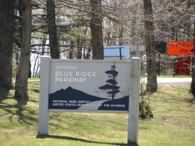
For some reason, my foot hurt, making it really painful to walk (I learned later I had cracked a metatarsal bone; don’t ask me how) so I departed without finding a local historic establishment for dinner and set my sites on the drive home — via Asheville, North Carolina, and through the Blue Ridge and Great Smoky Mountains.

I have decided that a solo meander is not conducive to big city exploration. Charleston is a charming Southern city, worthy of a couple days or a long weekend of exploration where one can ferret out the historical gems and quaint restaurants. Visit with a friend, spend the money and stay in the heart of the city, and act like a tourist — take the horse drawn tours, visit the market, go to the fort, walk the old streets and live the history of America.

“Toto, we’re not at the beach anymore”

Blue Bear needs a directionI followed the signs toward Myrtle Beach but somewhere around Charleston have to take a left turn.

As I leave the ocean and  beach behind, I will miss the smell of the salt air, the cry of the sea birds, and most of all the beauty of the sunrise accompanied by the music of the waves, whether soothing or stormy.

The interior of our country is filled with beautiful, majestic, serene, and exciting places and I enjoy all the variety, yet being at the ocean shore at sunrise is pretty hard to beat (though the shores of  the Great Lakes come close.)

The salt marshes of Georgia, the antebellum vibe of Charleston, the Blue Ridge Parkway and Smokey Mountain National Park await. Adventure on.


Way off the beaten track

Blue Ridge Mountains, TennesseeI have been meandering in the mountains of North Carolina and Tennessee. One thing about being in the mountains — you may be able to see for miles and miles but communication, whether by phone, radio, or other means gets lost behind one or more of those ridges.

I am back in civilization and with full Internet access, will continue to share the highlights of my latest adventures. Stay tuned.


Sunrise – Edisto Beach, South Carolina

img_8465-qpr img_8503-qpr img_8507-qprIf I could just stay right here for a few days I would but alas, since my meander was slowed by rain, and I have to be home for an April 26 engagement, sadly I must leave today so I might enjoy the sights and sounds of the rest of my trip. This is one place I will return to though.

Since this is probably my last day at the beach for a long while, I am so glad it was and is a beautiful beginning.

Perchance to sleep

I am a simple bear. When I travel, I like to just throw the sleeping bag in the back of the van and hit the open road. I have the freedom to go where I want, when I want to go, and stop or change directions whenever it suits me.

I also prefer this type of travel because of my chemical sensitivities. Hotels, in addition to being expensive, are filled with the residue of cleaning chemicals.

Because of the extensive storm system I have been dodging, I have been rained on at times. Other than the raindrops falling on my roof, which can actually be quite soothing, a little rain is only a mild annoyance, sometimes requiring me to wait out a shower before getting out and enjoying the clear light and fresh smell of a newly washed landscape.

With the concerns of loved ones and threats of thunderstorms last night, I opted for a hotel room. The storms never materialized, at least here, and I feel like a truck ran over me while I was sleeping, but I got the benefits of a hot breakfast, a hot shower (even if I did have to go to a different room to take it), and this view when I opened my eyes.

Morning forest view Almost as good as camping. Next time I will opt for the real thing though.

Map vs. GPS

Shortly before I left to head back North, I started to look at the map and pick a general direction. Lamenting that I did not have a North Carolina map, someone suggested that I didn’t need a map, that’s what GPS is for.

It is obvious that the person who said that has never meandered. A GPS may work just fine in telling you how to get from point A to point B, but that assumes that you know where point B is. If you are meandering, there is no point B only a general direction so GPS is virtually useless.

I do use it to tell me what road I am on and the speed limit, but face it the map on the GPS does not give enough detail to be of much use other than navigating around a strange town. It is handy for those times when I am “making time,” usually in the dark, on the Interstate because it lets me know how many miles it is to my exit so I can read all the fun town names on the road signs, not wondering where I am, and just drive.

A map gives you a big picture of where you are heading. Whether a state map, which shows those blue highways and other off the beaten track roadways, or my multi-state maps that give me a general view of options to choose, a map is something you can hold in your hand and consult without opening up a computer. Although Google works very well, it is dependent upon a signal on the phone, which is not guaranteed off the beaten path. Unplugging and meandering just seem to go hand in hand.

Salt marsh, St George Island, FloridaSalt Marsh, St. George Island, FloridaI read somewhere that only people over 40 have maps in their cars. I guess that makes me an old bear huh!!?

Map or GPS, which do you prefer on your meanders?

Ode to the Road

Late winter dreary, cloudy and cold
Driving toward spring
Endless prairie, dotted by white barns and farms
Thin sliver of light hints at promise of sun and warmth

Rivers and lakes – water sparkling like diamonds
Meander through forests – sun flickering through the trees
Eagles soar overhead as red tailed hawk eyes me
Clumps of daffodils nod to a coming spring

Wiggle and waggle southward
Narrow roads with no shoulders
Houses with wide porches, doors open, folks rockin’
A church on every corner like gas stations back home

Signs of spring – grass greening
Apple and almond trees shimmering white
Wild plum and redbuds – splashes of color amidst dark, leafless trees
Creeks tumble over rocky beds, rushing with snow melt

Over Mont Eagle, down toward Nickajack Lake
Warm sunshine entices, stop to hike
Cloudland Canyon, home of the Cherokee
Waterfalls over ancient rock faces – awe inspiring

Winter fingers reach out to nip at fingers and nose
Run, run, run to warmth
Meander lost
Georgia stretches on and on at break neck speed

Florida at last – slow lane once more
Cracker style houses, horse farms, and forest green
Live oaks drip with Spanish moss
Wildflowers paint the roadside – purple and pink, yellow and white

Pines and palmettos
Give way to salt marsh and sawgrass
Ocean views and beach stretching on and on
Journey’s end

The Scenic Route

In a favorite book of mine, “Blue Highways: A Journey into America,” William Least Heat-Moon wrote, “Had I gone looking for some particular place rather than any place I’d never have found this spring under the sycamores.”

That describes the beauty of taking the scenic route, getting off the Interstate — typically miles and miles and miles of straight, flat, and boring — and onto secondary roads, county highways, or better yet, those thin, wiggly lines on the map that wind around a lake, over a river, or through the forest.

Case in point, if you drive the Interstate North to South through Indiana, you travel through miles and miles of ancient lake bed, now flat land, however, go a few miles West and you traverse hills and rivers, past huge rock formations, Amish farms, and small towns — a wonderland that the average traveler, bad mouthing the boring drive, never realized existed.

At the beginning of his journey, Heat-Moon wondered if “Maybe the road could provide a therapy through observation of the ordinary and obvious, a means whereby the outer eye opens an inner one.”

Meandering backroadI can attest to the  truth of those words. Instead of flying past everything, seeing nothing, “meandering” the back roads forces you to slow down, see the hawk soar over the trees, hear the water babble in the creek, and snatch glimpses of another slice of life — horses grazing, children playing, the old folks rockin’ in the shade of their porch.

Blossoming trees, Georgia


Instead of billboards advertising gas prices or the next fast food restaurant or tourist attraction, homemade signs announcing “maters and taters” or asking “Are you willing to take a chance with your soul?” You literally go over the river and through the woods, whether to grandmother’s house or not. And you breathe — not only slower, as the stress of everyday life melts away, but cleaner, filled with the scent of apple blossoms, fresh grass, crunchy leaves, tumbling water, or pine.

Heat-Moon shares his father’s philosophy that “any traveler who misses the journey misses about all he’s going to get,” that a man’s (or woman’s) observations and curiosity, make and remake them.

Taking five full days to travel from Wisconsin to central Florida may seem like an eternity to some. “I could do it in 2 ten-hour days!,” they boast. This isn’t Name that Tune, so I will not respond with how fast I could drive it because for me, it is the journey that matters.

This was not a true meander; I had a particular place to be in a “reasonable” amount of time. That time expectation and the cold, blustery weather kept me moving southward, hundreds of miles a day. In the end, it was more like Heat-Moon describes as “turning the windshield into a movie screen in which I, the viewer, did the moving while the subject held still.”

Since each day, I took time to stop, look, and listen — watching wildlife, lunching by pristine waters, hiking trails past awe-inspiring rock faces and to roaring waterfalls, sitting by the campfire, and star gazing — I did not mind watching the movie that unfolded before me at times. In the end it was a good journey.