Sky Candy

If you have followed my adventures for any time, you know that I LOVE sunrise. Sunsets are awesome, but there is something about a dark sky evolving into light — sometimes with riotous color and sometimes soft pastels — that just makes my day!

Taxco being a mountain town with many ups and downs, there are many vantage points for overlooking the city. My room though, located on the fourth floor overlooking the valley to the East, offers the perfect vantage point for viewing the sunrise over the surrounding mountains.

I could lie in bed and watch the sun come up, if I wanted to, yet stepping out onto my terrace balcony, where I have an unobstructed  view of the “puesta del sol,” while breathing in the fresh morning air, is almost a spiritual experience. Each new day is a fresh palette, painting a new masterpiece never to be seen again. How can I miss even one?

I share with you here some of the more spectacular daybreaks. Grab a “cuppa” and sit back and enjoy the show.

This slideshow requires JavaScript.

The Ruins – Tehuacalco

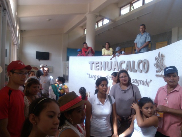
Not too far west of Ocotito is an archeological site, the ruins of an ancient indigenous people, known locally as “The Ruins.” Tehuacalco, or sacred place of water, was discovered only recently and opened in 2008.The site interprets a center of government and worship, which ruled over a vast area roughly covering all of Guerrero state, and cities to the north, to the Pacific coast, and all the way to Jalapa in the southeast on the Atlantic.

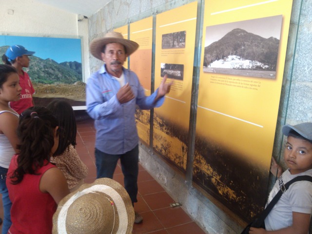
It has a modern interpretive museum and bi-lingual (Spanish and English) signage, though as part of a group of 38 Spanish speaking friends, ranging in age from 3 on up, I had little chance to read the signs.

Tehuacalco archeological site, MexicoSince the ruins were discovered buried pretty much intact, rather than torn apart and the stones scattered, it appears that this site was abandoned by the people (for some unknown reason) rather than discovered by the Spaniards. Its location, high on a remote mountain, and a lack of silver or gold, may have played a role in that outcome.

One of the four points (directional mountains, Tehuacalco archeological site, MexicoThe people who lived here, worshiped the god of rain and water (essencial to life) and chose this location because of the abundance of water. They built a high temple, which faced the four points (or directions), where on each season’s solstice, the sun came up directly over one of four neighboring mountains. (This indicates to me that they may have worshipped the sun as well, though they could have just been marking the seasons.)

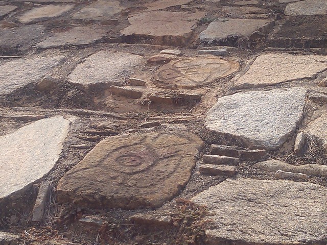
The building that housed their gods is gone now; all that remains is the temple mount. Below the temple is the government mount with some remaining ruins, several stellas (stone markers) which marked the passing of time (days, hours, and seasons), and the ball court.

Similar to other ball courts in Mexico and the Americas, this game, which was played by just two people, consisted of the players batting around a 5 kilo (about 11 pound) ball, made from a local tree trunk, using only their legs or shoulders (sort of like soccer or football if you come from these parts.) The object was to get the ball into a small opening in the wall at center court.

The ball goes here, Tehuacalco archeological site, MexicoThough the game was likely played every day, once a year, the two best players were selected to play to the death, literally. All the citizens would come to watch the match, standing above the court in the grassy area, one side rooting for each player.

The winner of the match was sacrificed to the gods (yes, I said winner), while the loser was ejected  from the society to fend for himself amidst wild animals and poisonous snakes —  live or die, never to return.

On the day of sacrifice, a procession moved along the sacred pathway and up the stairs and steep incline to the temple mount. Each level of elevation marking one step (level) closer to the gods. Only the priests, kings, and sacrificial victims were allowed to climb the stairway to the gods. The average person stood in a field below the temple and watched the spectacle as braziers lit up the night sky and shadowy human forms performed rituals and dances culminating in the sacrifice of the victim and his beating heart being offered to the gods.

I learned a couple of interesting things visiting this ancient site:

Ancient glyph, Tehuacalco archeological site, Mexico 1) What I have always thought (and been told) was a decorative way of building rock walls using small stones between the larger rocks, turns out to have a practical reason (though lost to most Mexicans today.) The small stones allowed for more movement in the wall during seismic events (earthquakes) and thus the walls were less likely to come tumbling down.

2) The interpreter told us that the original pozole, a special soup traditionally eaten on Thursdays, Sundays, and holy days in this area, was made using the arms and legs of the sacrificial offering. Each bowl was topped with a small piece of the sacrificial victim’s meat, which was supposed to bring strength and protection for the coming year to those who ate it. As the guide said, some of our customs today, have their origins in these pagan peoples.

After a hot, sweltering, but very interesting afternoon we headed down the mountain to cool off in the river. But that is another story.

Hasta luego (until later),

Canaveral National Seashore

As I mentioned in the last post, acres and acres of the land around  NASA’s Kennedy Space Center not needed for space agency business is preserved partly as a wildlife preserve (Merritt Island) and partly as a wild, natural seashore (Canaveral National Seashore.)

I spent most of a day, walking trails, visiting historical locations, and getting coated in the salt spray from storm tossed waves. I even got rained on but it was well worth it. Another national treasure just waiting to be explored.

Here are a few images for you to enjoy. More on the historical locations another time.

If you are near Florida’s Space Coast, be sure to take some time to take a walk on the wild side.

By the way, all this was happening while they launched a SpaceX rocket from the Kennedy Space Center.

The Scenic Route

In a favorite book of mine, “Blue Highways: A Journey into America,” William Least Heat-Moon wrote, “Had I gone looking for some particular place rather than any place I’d never have found this spring under the sycamores.”

That describes the beauty of taking the scenic route, getting off the Interstate — typically miles and miles and miles of straight, flat, and boring — and onto secondary roads, county highways, or better yet, those thin, wiggly lines on the map that wind around a lake, over a river, or through the forest.

Case in point, if you drive the Interstate North to South through Indiana, you travel through miles and miles of ancient lake bed, now flat land, however, go a few miles West and you traverse hills and rivers, past huge rock formations, Amish farms, and small towns — a wonderland that the average traveler, bad mouthing the boring drive, never realized existed.

At the beginning of his journey, Heat-Moon wondered if “Maybe the road could provide a therapy through observation of the ordinary and obvious, a means whereby the outer eye opens an inner one.”

Meandering backroadI can attest to the  truth of those words. Instead of flying past everything, seeing nothing, “meandering” the back roads forces you to slow down, see the hawk soar over the trees, hear the water babble in the creek, and snatch glimpses of another slice of life — horses grazing, children playing, the old folks rockin’ in the shade of their porch.

Blossoming trees, Georgia


Instead of billboards advertising gas prices or the next fast food restaurant or tourist attraction, homemade signs announcing “maters and taters” or asking “Are you willing to take a chance with your soul?” You literally go over the river and through the woods, whether to grandmother’s house or not. And you breathe — not only slower, as the stress of everyday life melts away, but cleaner, filled with the scent of apple blossoms, fresh grass, crunchy leaves, tumbling water, or pine.

Heat-Moon shares his father’s philosophy that “any traveler who misses the journey misses about all he’s going to get,” that a man’s (or woman’s) observations and curiosity, make and remake them.

Taking five full days to travel from Wisconsin to central Florida may seem like an eternity to some. “I could do it in 2 ten-hour days!,” they boast. This isn’t Name that Tune, so I will not respond with how fast I could drive it because for me, it is the journey that matters.

This was not a true meander; I had a particular place to be in a “reasonable” amount of time. That time expectation and the cold, blustery weather kept me moving southward, hundreds of miles a day. In the end, it was more like Heat-Moon describes as “turning the windshield into a movie screen in which I, the viewer, did the moving while the subject held still.”

Since each day, I took time to stop, look, and listen — watching wildlife, lunching by pristine waters, hiking trails past awe-inspiring rock faces and to roaring waterfalls, sitting by the campfire, and star gazing — I did not mind watching the movie that unfolded before me at times. In the end it was a good journey.

On being flexible

Because it has been hovering around freezing in the mornings and much warmer in the afternoon, I changed up my usual meander schedule. Instead of driving where I want to explore with fresh eyes and energy in the morning, I have decided to stop mid-afternoon and enjoy myself while the sun is high and the air is still warm,  leaving those freezing temps for drive time.

img_7110-qprI was really glad that I did, because after a lovely drive over the mountains anticipating lunch at my favorite rest area on Nickajack Lake and finding it closed (bummer) I had the opportunity to camp at Cloudland Canyon, a beautiful state park in North Georgia near Chattanooga (of choo-choo fame.) On travels this way in the past I have always wanted to at least go for a mid-trip hike but it has always been too windy, wet, or cold (seeing that I have always made this trip in the winter not spring.)


Despite it suddenly being an hour later (I am now on Eastern Daylight Time) there was enough time to select a campsite and take a hike. The Waterfalls Trail dropped 350 vertical feet from my campsite into the canyon below. It does this in a a little less than a mile; I think the ranger said something about over 900 manmade steps and that does not count the non-manmade ones!

This slideshow requires JavaScript.

The going down was not too bad as I kept stopping to take photos along the way. Yet, there is no getting around that basic rule of the universe — what goes down, must come back up. Now that was a hike to be remembered!

It was late and the sun was no longer shining in the bottom of the canyon but the waterfalls were spectacular. Well worth the effort. I already plan to do it again on the way home, weather permitting of course.

img_7100-qprFor the first time, the night was warm enough to sit outside after dark so I built a campfire, took the last of what I have been snacking on the last few days — grilled chicken, tomato, cheese, and pineapple — threw it all in a pan and feasted on a nice, hot, home cooked meal. Funny how the same foods can taste so different when you add a little ambiance.

I was hoping the morning sun would offer an opportunity to go back to the first of the falls and photograph it again. Though the day broke cold but with a promise of a sunny day, I took my time getting out of my sleeping bag. I started out for a gentle warm up along the rim of the canyon to the observation area. Was I glad I hiked the trail last night because a front came through that dropped the temperature drastically, accompanied with high winds, and even a few snowflakes. Time to hit the road.